reframe your future clouds-city circle static

How can the vantage of space give you strategic advantage on Earth?

Earth observation data offers incredible possibilities to businesses. Find out more about how to seize the opportunity for your organization.


In brief

  • A rapidly expanding constellation of satellites provides a unique vantage point for understanding the Earth and the accelerating change we’re experiencing.
  • With unprecedented access to space data, business must give serious thought to how they can use it to unlock value for customers, employees, partners and society.
  • The growing volume of Earth data captured by satellites unlocks innovative use cases and new opportunities for collaboration.

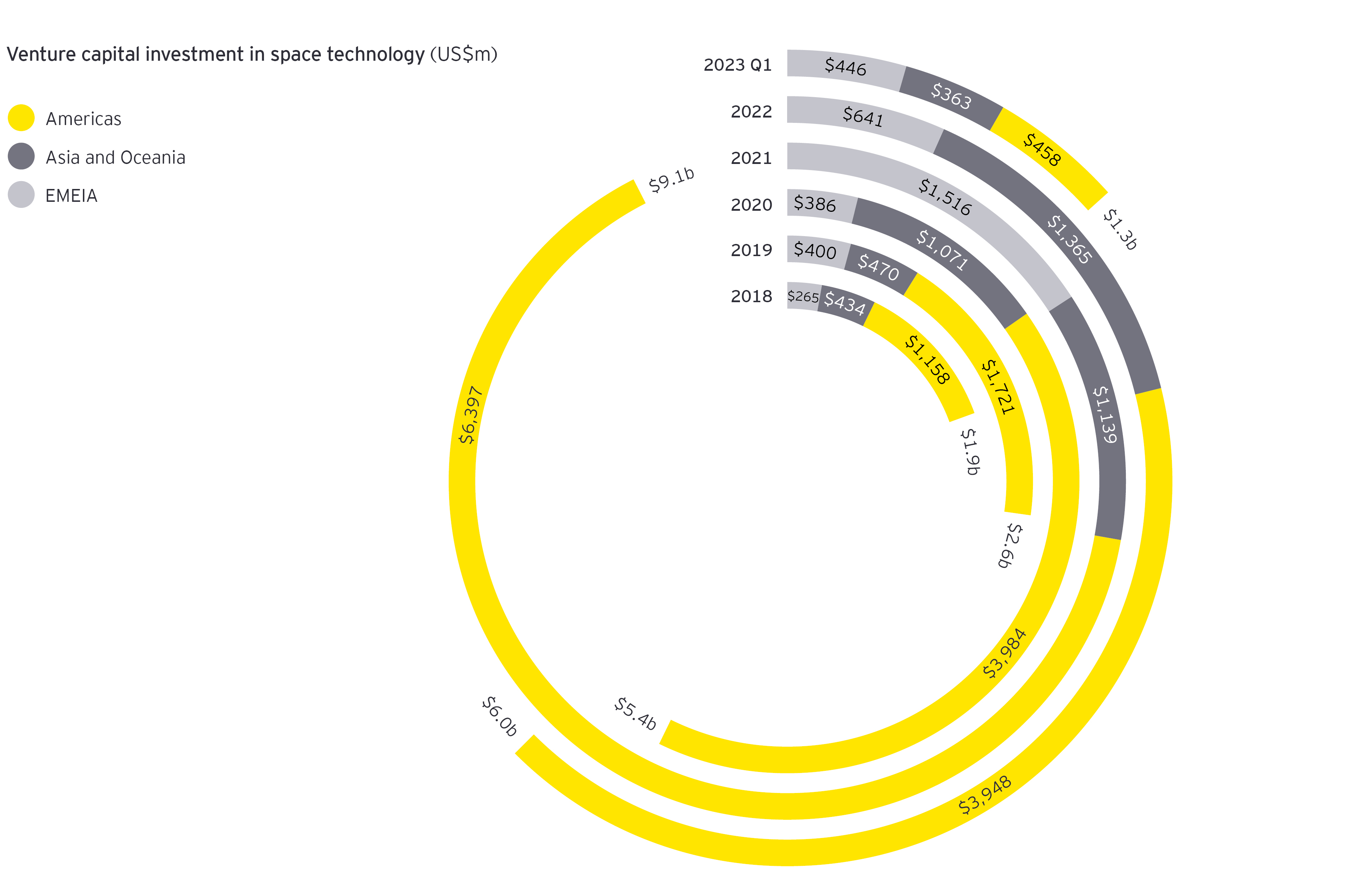
A quiet space revolution is underway today, focused not on outward exploration but on inward Earth observation and sensing by satellites.


A rapidly expanding constellation of satellites provides a unique vantage point for understanding the Earth and the accelerating change we're experiencing – in climate, biodiversity, infrastructure, land use and physical assets of all kinds.


The growing volumes of deep, multidimensional Earth data captured by satellites unlock innovative use cases and new opportunities for collaboration, but also give unprecedented operational transparency to the gamut of stakeholders globally.


The effective use of data has emerged as one of the most important drivers of value. With unprecedented access to a trove of space data now a reality, business leaders must give serious thought to how they can use it to unlock new value for their customers, employees, partners and the broader society they serve.


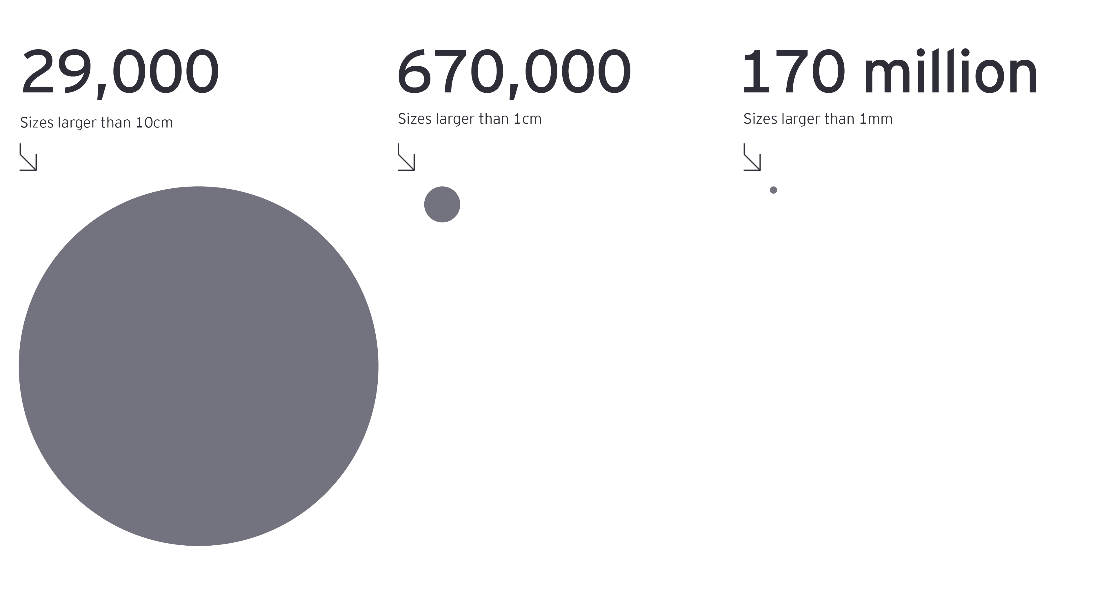
At the same time, the global commons of Earth orbit are becoming more crowded, creating commercial complications and collision risks, making it increasingly urgent to address the long-term sustainability of space. Space-based observation also raises important privacy concerns.


Space provides a strategic vantage point, opening a rich new seam of actionable data in a time of exponential change on Earth. This report shares some of the important possibilities, challenges and risks related to this data resource. We hope it helps organizational leaders develop an agenda for meeting this strategic imperative and capitalizing on the associated opportunities.


This is a summary article of the full report which covers the following topics:

  1. New capabilities, enablers and ecosystems
  2. A universe of use cases
  3. Space and sustainability on Earth
  4. Managing the new global commons
  5. The space data imperative
portland 3d landscape view south north natural color
1

Chapter 1

New capabilities, enablers and ecosystems

From GPS navigation to credit card transactions, satellites provide essential infrastructure services to our terrestrial economy.

Now, three key developments are unlocking novel capabilities and innovative use cases for satellite observation and sensing data:

  • Smaller, more powerful and cheaper satellites thanks to the decisive shift to commercial development of satellites over the last decade.
  • A suite of powerful enabling technologies increasing the accessibility and utility of Earth observation and sensing data, opening an array of use cases.
  • Fast-growing market infrastructure propelled by access to open-source data and substantial venture capital investment.


Advanced sensors

Just as the cameras in our smartphones have become increasingly sophisticated, satellite-mounted sensors are gathering deeper, granular, and more varied data, generating novel insights across a range of applications and industries:

  • Improved optical sensors reveal fine-grained views of our planet’s natural systems and human activity with commercial providers achieving resolutions of 0.3m².
  • Powerful hyperspectral sensors on satellites capture data on physical characteristics at the molecular level (e.g., soil minerals, vegetation types, emissions, water quality).
  • Synthetic aperture radar provides visibility where optical instruments can’t, penetrating clouds and smoke, and “seeing” in the dark, to generate high-resolution ground imagery.

Computing power, artificial intelligence (AI) automation and edge intelligence

Sifting through the terabytes of satellite data beamed to Earth daily to unearth relevant intelligence and insights is a critical step in extracting business value.

Three key technologies are coming together to make the process more efficient and democratize access to space data insights:

  • Cloud-based applications, handling the storage and computing requirements of processing voluminous space data.
  • Machine learning (ML), automating image analysis.
  • Edge AI capabilities, allowing satellites to process imaging data onboard and relay only the most relevant insights to the ground in almost real time.

“The compute power and abstraction of cloud tools allow a broader set of users to take the large volumes of amazing Earth observation data and turn it into actionable insights,” says Nicholas Moretti, Senior Program Manager, Microsoft Azure Space.

Communication infrastructure

Connectivity is imperative to get our hands on timely satellite-generated data. Here, too, technology plays an enabling role:

  • Maturing free space optical communication is transmitting growing volumes of data to the ground and back more quickly.
  • Improved ground station infrastructure is increasing accessibility and reducing transmission and reception latency.

Fast-growing market infrastructure

Propelled by access to open-source satellite data and substantial venture capital investment to leverage these new capabilities, the market infrastructure and value chain linking satellites and the data they collect for enterprises are evolving quickly:

  • An extensive ecosystem of providers is emerging to on-ramp satellite-based intelligence into enterprise strategy and operations.
  • Satellite data is being combined with other datasets, such as IoT and mobile phone data, to paint a more detailed picture of the multiple variables affecting an enterprise’s operations, assets, customers, productivity and more.
The space innovation is growing quickly

international space station orbiting earth in space
2

Chapter 2

A universe of use cases

NASA and the European Space Agency (ESA) moved to make satellite data freely available, spurring the development of business use cases.

With Earth observation data now free and open to use, interested individuals and more crucially, commercial companies began to mine it, package it and sell solutions.

“Business leaders still need education on what Earth observation data can do for them,” says Dr. Brian Killough, former NASA Earth Science leader. “They are asking, what is being measured, and how do I infuse it into my business? We are just beginning to unlock the huge potential of this treasure trove of insight.”

Speeding disaster detection and response

Perhaps the most public use case for satellites is providing first responders with the situational awareness to efficiently allocate resources to those most in need. Machine learning applied to satellite data helped track the Australian bushfires in 2020. Similarly, satellite imagery aided the rescue and recovery efforts after New Zealand was hit by cyclone Gabrielle earlier this year.

”We are going to revolutionize disaster response by leapfrogging communications and data technology,” says Dr. Rebecca Allan, Co-Director Swinburne Space Technology and Industry Institute. “Edge computing on satellites and dedicated grounds stations will remove steps in putting critical imagery of ground conditions in the hands of first responders, reducing the turnaround time from a day or more to hours.”

Monitoring asset and infrastructure risk

Another important use case for remote sensing and observation is assessing key assets and infrastructure for exposure to natural hazards and the risk of operational disruption. This capability particularly benefits businesses in sectors with critical, always-on infrastructure, such as energy, water and transportation.

Satellite imagery helps asset-heavy enterprises:

  • Plan for contingencies and redundancies.
  • Monitor physical infrastructure not only for problems but also signal for preventative maintenance.
  • Avoid expensive “truck rolls”.
  • Minimize human interactions with hazardous infrastructure.

Improving supply chain resilience

The need to build diverse and more resilient supply chains has become urgent in the wake of disruptions stemming from the COVID-19 pandemic. Satellite data helps to optimize routes and monitor production levels by assessing activity levels at factories, ports and other supply chain links. Given the imaging resolution now possible, commodity traders can even assess the volume of oil production and trade from the shadow cast by oil tankers as they cross the oceans.

Combined with demand forecasts and other data, satellite data can support improved supply chain efficiency and inventory planning.

Selected sector-based use cases

Weather and climate forecasting

Resource mapping

Ecosystem management

Disaster management

Agriculture

  • Optimized immediate/long-term decision-making for planting, harvesting and inputs
  • Resilience to gradual climate effects
  • Efficient measurements or longitudinal datasets
  • Precision agriculture
  • Water demand estimation
  • Crop inspection
  • Yield estimation/forecasting
  • Identification of pests and diseases
  • Monitoring environmental degradation
  • Soil monitoring
  • Carbon credits from sustainable farming
  • Mitigation/preparedness for slow (e.g., drought) or rapid onset (e.g., flooding) natural disasters
  • Biosecurity and protecting against disease
  • Asset valuation

Forestry

  • Optimize forest locations accounting for forecasted weather and climate
  • Rapidly identify/intercept illegal logging
  • Increase supply chain transparency
  • Optimize harvest decision-making
  • Carbon offset baselines
  • Measure forest coverage/create forest inventories
  • Manage/monitor forest reserve
  • Monitor land use change, forest carbon stocks, resource health
  • Prevent degradation/manage restoration
  • Land applications and habitat characterization
  • Assist credentialing-compliant resource use
  • Response planning
  • Predict, monitor and map forest fires
  • Post-fire restoration/rehabilitation

Fisheries

  • Extreme weather preparedness
  • Optimize operational decision-making: stocking/harvest time, quota purchases, labor, equipment, fee management
  • Switch fishing gear due to regime shifts
  • Monitor/prevent illegal fishing
  • Predict areas of fish concentration
  • Fish farm site optimization
  • Fish stock modelling
  • Aquaculture carrying capacity
  • Project climate change impacts on resources
  • Monitor water quality
  • Enhanced decision-making for aquaculture management
  • Predict/identify/monitor harmful water quality events
  • Map marine-protected areas
  • Assist credentialing compliant resource use
  • Mitigate/prepare for impacts of natural hazards
  • Storm response: sortie or additional precautions to protect boats
  • Fishing boat search and rescue
  • Assess habitat vulnerability/damage
  • Site grey/green resilience infrastructure

Insurance

  • Risk modelling
  • Risk prevention
  • Claims assessment and approval
  • Loss measurement
  • Value/monitor assets and resources to influence premiums
  • Assess risk of disease outbreaks
  • Climate risk assessments and impact-modelling
  • Benchmark policy holder’s ecological performance
  • Map risk-prone areas to inform premiums
  • Faster and more efficient response to disasters, reducing damages and insured costs

Mining/energy

  • Predict extreme weather and oceanographic conditions
  • Prospecting and exploration
  • Meet regulatory requirements
  • Monitor remote infrastructure
  • Monitor environmental impacts/minimize damages
  • Identify/prevent illegal mining
  • Situation monitoring: oil spills, tailings dams, chemical leaching, etc.
  • Prepare for/mitigate natural disasters; guide infrastructure hardening

New skill sets and capabilities required

Numerous use cases demonstrate the opportunity to drive value with Earth observation and sensing data. However, realizing this value requires specialized skills and capabilities which most companies don’t currently possess.

While custom high-resolution images can be procured within hours, teams need to be able to bring together AI, machine learning, and data science to distill insight from them.

For business leaders, the question of whether to build in-house capabilities or work with business partners will depend on several factors:

  • Anticipated breadth of use of Earth observation and sensing data.
  • The degree to which the data and capabilities will be strategic to the business.
  • The opportunity for spill-over benefits into the organization’s innovation and technology strategy.
Aerial view drone shot of rice terrace in Tegallalang Ubud in Bali Indonesia.
3

Chapter 3

Space and sustainability on Earth

One of the most clear, compelling, and urgent applications of satellite imagery and sensing is to achieve sustainability on Earth.

Satellites provide both big picture and close-up perspectives, generating increasingly rich data on the current state of the environment and how it’s changing.

As companies contend with new sustainability reporting expectations and requirements, the democratization of space data creates new opportunities and new accountability:

  • Growing volumes of rich space data offer companies a critical resource for assessing, reporting on, and improving their sustainability performance.
  • An expanding ecosystem of public and private organizations utilizing this data creates new opportunities for productive partnerships to accelerate corporate action on sustainability.
  • Space data empowers stakeholders to monitor the sustainability performance of companies and hold them accountable for their pledges, increasingly limiting the ability of companies to selectively disclose and reducing their control over their sustainability narratives.

“Now is the time for private and public sector leaders to understand what Earth observation data reveals about their global footprint and impact, both to manage sustainability risks and accelerate progress on climate, biodiversity and other goals,” says Amy Brachio, EY Global Vice Chair of Sustainability.

Eying global greenhouse gas (GHG) transparency

Climate-focused non-governmental organizations (NGOs) are leveraging open-source satellite data and AI to quantify and inventory the largest individual sources of GHG emissions.

Climate TRACE, a non-profit coalition, has mapped over 80,000 emitting physical assets globally in two dozen sectors, in addition to providing independent emissions estimates for every country on the planet.1 The organization synthesizes data from 300 satellites and more than 11,000 sensors with other ground truth data sets to train AI or ML algorithms, which can then be used to make estimates globally.

“The public availability of satellite data has been tremendously helpful to us, along with advances in artificial intelligence and machine learning. We’re building on tried and tested analytical approaches and massively expanding them globally,” says Lekha Sridhar, Senior Policy Analyst with WattTime, one of the Climate TRACE coalition member organizations.

Other NGOs are launching their own, purpose-built, satellite missions to identify and quantify emissions sources. The Environmental Defense Fund (EDF) and Carbon Mapper both will have satellites focused on detecting methane, a greenhouse gas 80 times more warming than CO2.

“Satellite emissions monitoring also provides an important opportunity to build confidence in underground carbon capture and storage,” says Mathew Nelson, EY Oceania’s Chief Sustainability Officer. “Monitoring and verifying the lack of emissions from carbon capture and storage (CCS) sites could help answer concerns about leaks and accelerate the adoption of these solutions.”

Together, organizations such as Climate TRACE, EDF, and Carbon Mapper will illuminate the climate performance of high-emitting industries at a very granular level while offering a hand of collaboration to companies seeking to improve.

Unlocking capital for nature-based carbon solutions

Concerns related to the monitoring, reporting and verification of nature-based carbon offsets and removals have constrained investment in both established classes of projects (e.g., forest preservation) and emerging ones (e.g., soil sequestration).

Increasing confidence in the additionality, performance and permanence of nature-based projects would help unlock the capital needed to scale carbon markets.

Satellites are already playing a role as organizations:

  • Combine satellite remote sensing data with AI to define, quantify and certify carbon projects.
  • Use satellite data to independently assess and rate nature-based projects, often highlighting disparities with reported performance.

Given the growing number of satellite data sources, coordination among standard-setting organizations on the use of satellite data and a system of assurance on satellite imagery would also bolster confidence in nature-based credits.

LEAPing into TNFD reporting with satellite data

Satellite data will likely become an important tool for many companies assessing and disclosing their nature-based risks under the Taskforce on Nature-based Financial Disclosures (TNFD). The TNFD’s four-step “LEAP” assessment framework (released in September 2023) asks companies to report on nature-related dependencies, impacts, risks and opportunities with a comprehensiveness many organizations will find both novel and challenging.

Satellites’ ability to provide both systemic and pinpoint insights into ecosystems anywhere can help many corporates to meet this assessment challenge, particularly in the “L” step (Locate interfaces with nature) and the “E” step (Evaluate dependencies and impacts).

While financial institutions typically do not possess the geolocation data of the physical assets and operations of their portfolio companies, satellite data can support TNFD assessment of more discrete investments (e.g., project finance, real assets, infrastructure).

Meeting the challenges of nonfinancial reporting

The ability of satellite data to provide insights into a wide range of sustainability issues can support voluntary and required nonfinancial reporting. Earth sensing and observation data can be applied to:

  • Establishing ecological baselines and impacts relative to a company’s operational footprint.
  • Determining local ecological thresholds and biodiversity characteristics.
  • Providing insights into the sustainability performance of value chain participants.
  • Substantiating sustainability claims and progress.

Integration of double materiality principles into national and international reporting frameworks, such as the EU Corporate Sustainability Reporting Directive, will likely accelerate the use of satellite data in nonfinancial reporting. As companies undertake impact assessments to establish double materiality, satellite data can provide important data related to natural systems and resources.

“The ability of satellites to provide multi-dimensional insights into natural systems over time – climate, pollution, water, biodiversity and more – allows companies to better understand the context in which they operate and how their operations impact, and benefit from, biospheres,” says Ben Taylor, EY Global Climate Change and Sustainability Strategy and Markets Leader. “This could make satellite data an important contributor to companies’ baselining, target setting, and monitoring of progress on sustainability.”

The stars are falling
4

Chapter 4

Managing the new global commons of Earth orbit

Realizing the commercial and social benefits depends on using it sustainably and equitably and making it systemically resilient to collision risks.

Existential risks

The concern of collision risk is growing as operators put new constellations of satellites into orbit without deorbiting many defunct or failed pieces of hardware. Tiny pieces of debris can be lethal in the space environment. The task of keeping track of and maneuvering around them increases in complexity daily.

Amount of space debris chart 3840px

A runaway cascade of collisions that knocks out global communications and navigation – the so-called Kessler Syndrome – presents the worst scenario.

A careful analysis of the system complexity of the Earth’s orbit is warranted. From the COVID-19 pandemic to the war in Ukraine, our recent global experience underscores that low-probability, high-impact events occur. With growing geopolitical tensions, even a collision short of a Kessler event could lead us into uncharted territory.

Commercial complications

The increasingly complicated operating environment is the most immediate concern for commercial space operators. No central “space traffic control” coordinates mission activity as the growing number of objects in space reduces time and room for maneuvering.

Today, the owner of a satellite on a trajectory to impact another object must directly contact the other parties at risk to work out a plan to avoid collision. This diverts satellite resources from fulfilling customer orders, resulting in delay or loss of revenues.

New launches are becoming more difficult as time windows narrow due to the growing density of objects in orbit. “We’ve seen launch windows going from three hours to as little as three minutes in some cases,” says Peter Beck, CEO of Rocket Lab, who is pessimistic that any central coordination will be put in place without a serious collision event.

Privacy risks

The increasing resolution, ubiquity and open-source availability of satellite imaging create a growing ability to observe individuals, especially when combined with other forms of data and AI (e.g., mobile data, city or residential video, facial recognition).

Before we encounter unintended privacy consequences, governments, civil society, and the private sector must confront important questions, including:

  • How do privacy regulations apply to space observation data?
  • What is the right trade-off between the beneficial uses of space observation data and individual privacy?
  • How can regulators keep up with the pace of technology development and new applications?

“The ethics and governance of Earth observation have not been discussed much, despite the growing capabilities and volumes of data collected by private entities. Managing these risks will be hugely important because misuse of observation data — intended or not — could cause operators to lose their social license to operate,” says EY Oceania’s Chief Sustainability Officer, Mathew Nelson.

New challenges, new players and new governance

How do we prevent a tragedy of the commons in Earth orbit? Engaging in long-term thinking about the sustainability and governance of orbital space is essential.

“We must understand the systemic dynamics of space, the likely growth in space debris, and how these factors could affect the future use of space – in other words, the inheritance our generation will leave in space for future ones,” says Hugh Lewis, Professor of Aeronautics and Co-director of the Centre of Excellence in In-situ and Remote Intelligent Sensing at Southampton University.

Hubble space telescope above earth
5

Chapter 5

The space data imperative

Space is becoming an increasingly valuable strategic vantage point, offering a unique perspective on the enterprise geophysical ecosystem.

With unprecedented access to this rich trove of new data now a reality, enterprises must give serious thought to how they can use it to unlock new value for their customers, employees, partners, and the broader society they serve. So how can they get started?

An action agenda for space includes:

  1. Begin acquiring the skills, capabilities and partners needed to utilize space data.
  2. Start small, pilot, then scale up, focusing on areas where space can bring immediate savings.
  3. Put space into your innovation scanning processes and begin integrating it into your innovation ecosystem.
  4. Create safe testing environments for mission-critical applications – redundancy will have to be designed for.
  5. Plan for ground truthing, a critical process for developing and validating AI applications that scale and automate the analysis of space data.
  6. Consider your build vs. buy strategy by considering how important space is to your business. Partners can accelerate your value from space data.
  7. Don’t silo space data. Effective data integration will be key: satellite data becomes another source of data that is accessible and a source of insight across the organization.

Anthony Jones, EY Space Tech Leader & Oceania Assurance Innovation Leader, contributed to this article. 

EY Space Tech Lab report

Explore the drivers behind this data revolution and learn how it can offer a unique perspective and strategic advantage for your business.

Navigate your AI journey

Build confidence, drive value and deliver positive human impact with EY.ai – a unifying platform for AI-enabled business transformation.

Summary

Earth observation data is now accessible to all businesses, offering incredible possibilities. From forecasting vegetation growth to monitoring erosion risks, the opportunities are extensive. Business leaders must give serious thought to how they can use it to unlock new value for their customers, employees, partners, and the broader society they serve.